
OruxMaps GP
by jose vazquez
Version 100,000+ 💾 11 Mb
📅 Updated Eligible if bought after 7/2/2016.
Learn
A tool for outdoor activities.
Features OruxMaps GP
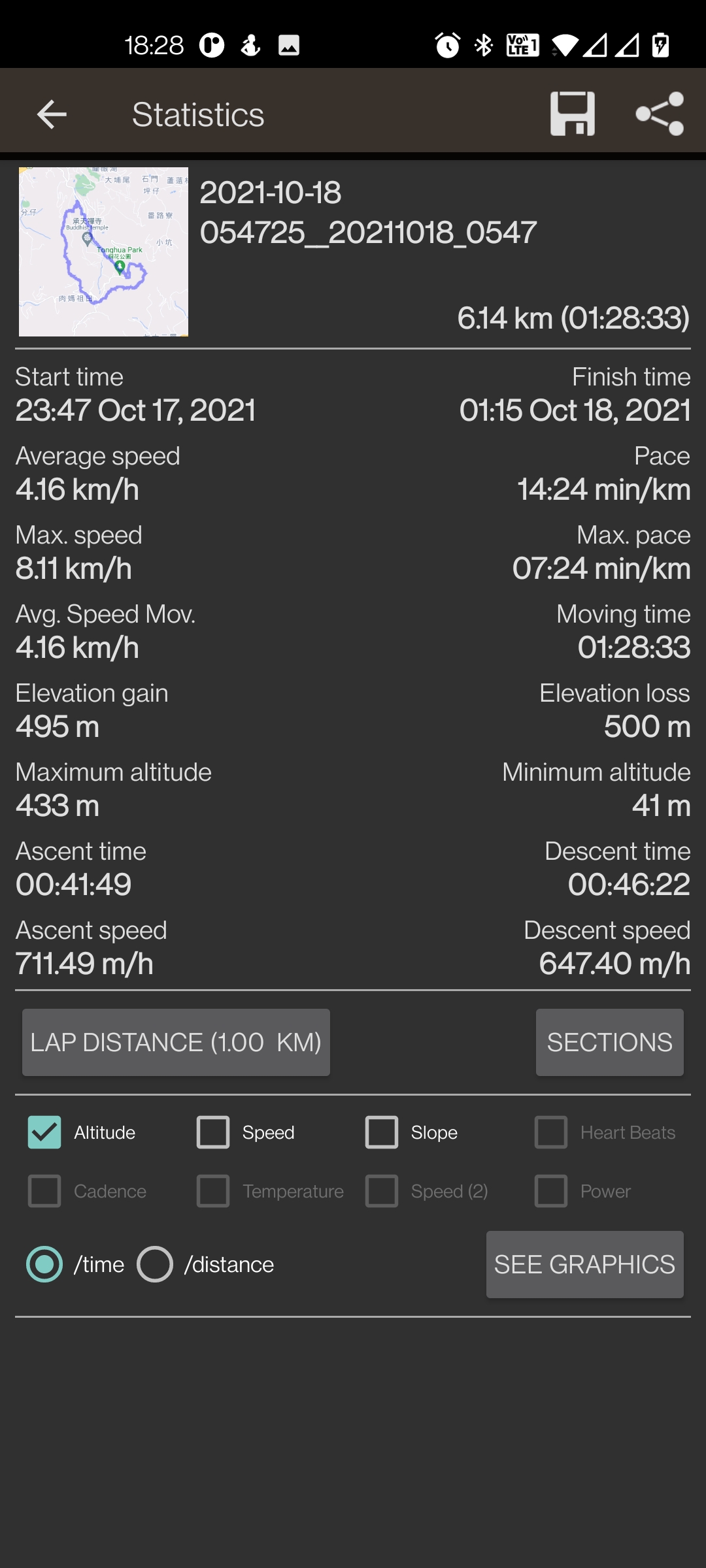
You can use OruxMaps for your outdoor activities.It is an Online and offline map viewer.
With this app you can use different map formats, like GeoPDF from USGS store, GeoTIFF maps, .ozf2, .img garmin (vectorial, no full support is provided), .mbtiles, and others.Online maps: You can use the application as a WMS and WMTS online map viewer.
Download online maps for offline use.
NOT ALL ONLINE MAP SOURCES ARE NOW DOWNLOADABLE.
SELECT ANOTHER SOURCE IF YOU CAN NOT FIND THE OPTION TO DOWNLOAD A MAP.NEW!
Added featured Mapbox and Google online maps (subscription required).
You can register into OruxMaps servers, but it is not mandatory, the app will work without this step.
If you register an account, the app will ask for various personal information, including an email account, date of birth, sex, weight and height.
This data will be stored on an OruxMaps server, and will not be shared with any other user, person or company; they are only at your disposal.
If you delete your account, that data is deleted from the server.If you want to use the multitracking option, the app will ask you to choose in your contacts the emails of the users with whom you want to share your position.
The email of these people will be stored on the server, so you can share your position with them.
These emails will only be used for this purpose.
If you delete your account, this information will also be removed from the server.
Support to multiple external devices, like external GPS, heart rate monitors, (including bluettoh smart 4.0 devices), bike cadence and speed, bike power, ANT+ (speed, cadence, heart rate, distance, cycle power, temperature).
It also can be used to control the tire pressure/temperaure.And you can connect to AIS information systems for nautical sports, using Wifi, BT or USB.
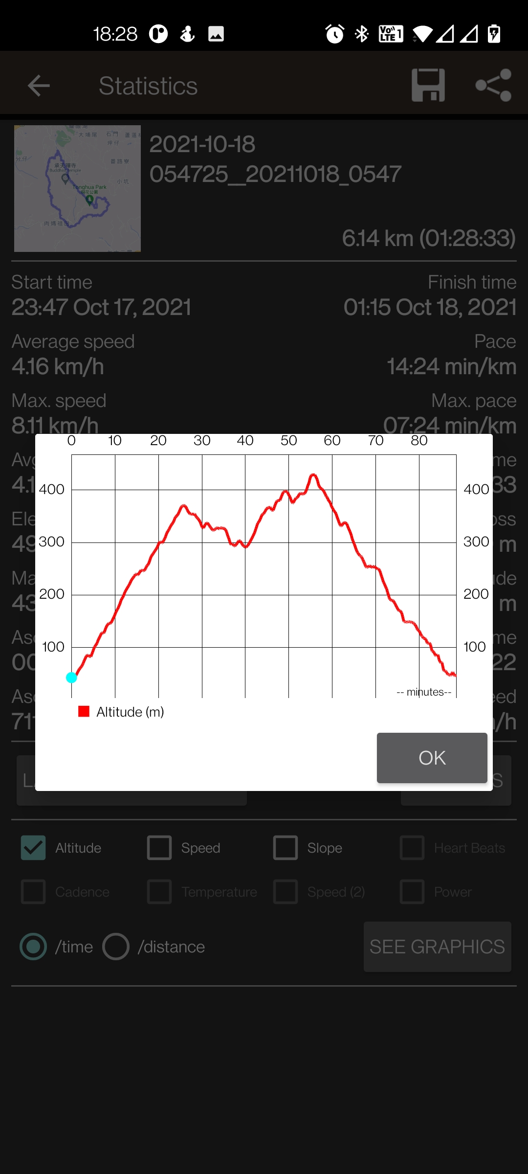
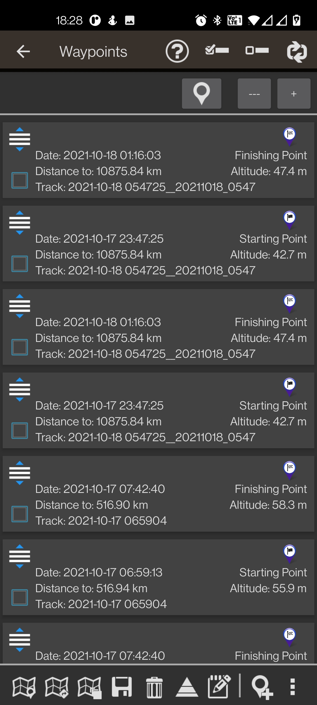
You can see Routes and Tracks in different formats, like KML KMZ, TCX, FIT, CSV, SHP and GPX.Share your position with your friends, display the position of your friends in your device.Follow routes, with different alarms to alert you if you are near a waypoint, or you are far from the route.Geofence/exclusion zone alarms with KML/KMZ overlays.Create/save wayponits, attaching photo/audio/video extensions.Custom Waypoint types, with your own icons.
Attach forms to the Waypoints.Basic support to Geocaching.Correct the altitude of your tracks/routes using DEM files (offline) or online services.Track editor tool.
Modify track points (add, remove, move) if they are wrong.Search/download tracks from different sources, like gpsies.com Search or create tracks using online services from Graphopper or offline using Brouter app.Support to Wear OS.
There is a Wear OS app that connects and shows information about the main app.
The Wear app is dependent on the phone app.
It wont work properly without it.
The Wear app needs the phone app to have access to background location to receive positioning.
More information on the website.News v.8.5.5: —>Bug correction.
Secure & Private
Your data is protected with industry-leading security protocols.
24/7 Support
Our dedicated support team is always ready to help you.
Personalization
Customize the app to match your preferences and workflow.
See the OruxMaps GP in Action
What Our Users Say
Don't just take our word for it. Here's what our users have to say about our Android app.
"Dual apps is not supporting"
Anand Anand
"So complicated to use."
EDUARDO VAZQUEZ TALAVERA
"I've used the free version for a few years for MTB. Why not spare some money for such an awesome app. Thanks for developing it."
Giorgos MetalHeart
"Wonderful app. Very powerful, very customizable. Steep learning curve. Would love Garmin Varía integration."
George Scorer
"Wear OS companion app can be improved. With View ranger gone, OM could be the one to replace it, but some work needs to be done (wear os offline maps download, gpx track following w/o smartphone etc.)"
Dario Zagallo
"All working and seems was Android not Ourx problem, thanks Jose. Broken since last update, could be the android update but can't track routes or load previous tracks to follow. Have been loyal user for years hope it's fixed soon because it's the best walking app. Galaxy s21 Android 12."
Kasabugu
"Excelent"
Eli Leshem
"Excellent and highly customisable app. Great as an alternative to now dead VR."
M M
"There is no Google Hybrid and Google Earth in its Switch Map option, in its free version it is in the Switch Map option."
VIRENDRA ORAON
"Can you develop iphone version?"
Waqas Mahmood
Get the App Today
Available for Android 8.0 and above